The sailor who drew the world beyond the forest of masts – Busuioc Gabriela-Natalia
The Age of Discovery has brought many great feats to the progression of the human society as a whole along with also bringing infamy to numerous explorers’ names at the time. Between them is found Piri Reis, a Turkish navigator, geographer and cartographer who had gained infamy from his days working in The Ottoman Empire’s naval fleet and his impressive maps he had drawn during his life.
In his early life, Piri Reis worked as a corsair under his uncle’s wing, Kemal Reis, who taught Piri the trades of sailing and privateering. Apart from working 14 years on his uncle’s ship, Piri Reis also served in the empire’s naval force and participated in a lot of military campaigns which, in the end, led him to gain the title of “Reis” (Admiral). Unfortunately, at the end of his life around 1553, he was executed by beheading for his actions made during the last Egyptian campaign he had participated in, one of the reasons being the abandonment of his fleet.
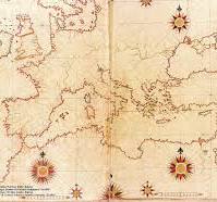
However, Piri Reis hadn’t just worked as a sailor but he had also drawn multiple maps during his service which were relatively accurate for the time. Amongst his maps there’s his most valued and impressive work “Kitab-ı Bahriye” (The Book of Navigation) which includes one of the oldest known maps of the continents including the New World which at the time had just been discovered. According to the map’s legend, during the drawing process there had been used a lot of charts and world maps including Christopher Columbus’ map of the West Indies and the newly drawn Portuguese maps of Asia.
In the end, Piri Reis’ feats and maps still spark interest in today’s world for their intrigue as many unanswered questions about his works still linger in present time conversations. Many ships and academic institutions bear his name such as the Piri Reis Vocational and Technical Anatolian High School located in Tuzla, Istanbul.